
Tracy ZIP Code Coverage
City information lists six ZIP codes in the wider Tracy postal context. The city GIS polygon layer recognizes four of them. That difference is not a mistake to smooth away. It shows which postal codes have a mapped city layer and which belong to PO boxes, rural places, or a separate municipality.
| ZIP | Areas covered | Post office | Notes |
|---|---|---|---|
| 95376 | Central, north, and east established Tracy, including downtown and civic areas | Tracy main office, 125 W. 9th St. | Standard delivery; many civic and library addresses |
| 95377 | South and southwest newer Tracy growth areas | Tracy | Standard delivery; city GIS polygon |
| 95304 | Rural east and northeast Tracy mailing area | Tracy | Substantial unincorporated territory; postal city is not incorporation |
| 95378 | Tracy PO boxes | Tracy | Non-geographic and PO-box-only; no neighborhood polygon |
| 95385 | Vernalis and rural southeast context | Vernalis | Unincorporated; city list includes it, GIS city polygon does not |
| 95391 | Mountain House and west-northwest area | Mountain House | Separate incorporated city, not Tracy city solely from older mailing use |
The USPS ZIP lookup is the address-level check for a mailing label.
USPS answers the delivery question. County and city GIS answer the land and jurisdiction question. The two should be saved together when a ZIP result will guide a records search.
Tracy ZIP 95376 and 95377
ZIP 95376 covers much of established Tracy, including the downtown and civic core, the main Tracy post office route, and many familiar public addresses. ZIP 95377 serves southern and southwestern newer growth. Both are standard delivery areas and both can be tied to a parcel when the District Viewer returns the ZIP attribute.
A ZIP code directory search can therefore be useful for a first pass through a known address set. It cannot return all residents. Use the ZIP to test a name in a state service that accepts ZIP narrowing, or to sort a known set of parcel APNs. Then verify the street, city limit, and post office fields rather than assuming every 95376 or 95377 address sits within the same subdivision or council district.
Growth labels such as Downtown, Central Business District, Tracy Hills, Tracy Village, Cordes Ranch, and Northeast Industrial Areas help explain why postal and planning categories can differ. The labels come from city development material and are not replacements for a parcel or legal description.
Tracy ZIP 95304 Rural Edges
ZIP 95304 is a Tracy mailing area with substantial unincorporated land east and northeast of the incorporated city. A 95304 address may therefore lead to a county planning, permit, code, or service trail rather than a Tracy department trail. The postal city alone does not prove city jurisdiction.
Check the county GIS City Limit, Sphere of Influence, Annexation, Post Office, and ZIP attributes. City Planning assigns a project location and can accept a milepost, cross streets, or coordinates when no address has been assigned. San Joaquin County Community Development uses an APN or address number and street name for unincorporated work.
The mismatch is useful. It tells a researcher to split the search by custodian before asking for records. A parcel inside the sphere but outside the city may have county land-use history even if its mail says Tracy.
Tracy ZIP 95378 and 95385
ZIP 95378 is a PO-box-only code. It does not describe a neighborhood, a set of adjoining parcels, or a population area. It can help route mail, but it cannot be used as a geographic proxy for residents or streets.
ZIP 95385 points toward Vernalis and a rural southeast context. The city’s prose list includes it, yet the city GIS polygon layer does not. Searchers working from 95385 should confirm whether the address is in Tracy, Vernalis, or county territory before choosing a city office.
- PO-box ZIP
- A code used for post-office boxes rather than a mapped delivery area.
- Postal city
- The city label used for mail routing, which may not match municipal limits.
- Carrier route
- A delivery route detail that helps USPS, not a public resident roster.
These codes show why “residents by ZIP” is a narrowing phrase, not a promise of a complete list.
Tracy ZIP 95391 Boundary
ZIP 95391 maps to Mountain House, with the GIS post office field naming Mountain House. Mountain House is a separate incorporated city. An older or informal Tracy mailing reference must not override the present city and county jurisdiction shown by the parcel and city layers.
When a name or address sits near the western or northwestern edge, record the postal city, ZIP, incorporated city, county, and sphere of influence as separate fields. That list makes it easier to send a request to the right custodian and prevents a ZIP code directory from blending distinct communities.
The city’s 2025-26 council districting archive adds another boundary. District maps and community-of-interest material may cross a ZIP or subdivision label. Political geography is a civic context, not a household directory.
Finding Tracy Residents by ZIP
A ZIP-keyed lookup works when the source actually accepts ZIP as a field. California Unclaimed Property does. The county District Viewer returns ZIP after an address or APN search, but does not let a user search for every parcel by ZIP. The county tax portal searches Assessment, Fee Parcel, or Street Address. The recorder is party-indexed. The voter system is authenticated or purpose-limited.
- Verify the address and ZIP with USPS, keeping the full street label.
- Use the county GIS parcel search to capture APN, situs, city limit, and post office.
- Choose the record source that fits the question, such as a deed, court case, business filing, or historical directory.
- Use ZIP as a narrowing field only where the portal documents it, then add a name, city, or record date.
- Check a second custodian before treating a ZIP result as the same Tracy resident.
A ZIP code directory can sort geography. It cannot fill the gaps left by renters, unlisted household members, protected voters, and historical records.
Tracy ZIP Search Fields
The state Unclaimed Property search is one of the clearest ZIP-capable tools in the research. It requires one of Last or Business Name or Property ID. First Name, City, and ZIP Code are optional narrowing fields. Exact matches appear first, followed by similar names. The service is free and uses Search, then Claim and Continue to File Claim buttons.
| Last or Business Name | Text; one of the required starting fields. |
|---|---|
| Property ID | Text; an alternative required starting field. |
| First Name | Optional text narrowing field. |
| City | Optional text narrowing field for the last reported locality. |
| ZIP Code | Optional text narrowing field; it does not prove a current address. |
The California UCC search provides another geographic contrast: city and state filters can narrow a debtor or secured party, but a filing relationship is not a residence.
Use the field’s stated meaning. A last-reported ZIP is not a live resident address, and a UCC city filter is not a parcel search.
Tracy ZIP GIS Layers
The city’s open-data ZIP layer exposes ZIPCODE, POSTOFFICE, and APCITY fields in a distinct-value query. The service supports JSON, GeoJSON, and PBF and caps a result at 2,000 records. City GIS also separates address points, street centerlines, city limit, annexation, sphere of influence, ZIP, and parcel layers.
The Tracy ZIP GIS layer shows which postal areas have mapped city geometry.
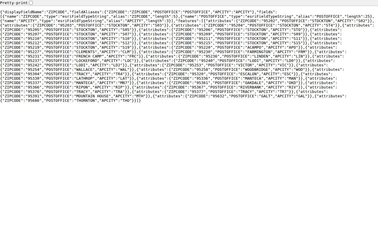
The layer recognizes 95304, 95376, 95377, and 95391. The missing 95378 and 95385 polygons reflect their PO-box or rural context. A parcel result, not a ZIP label, decides which city or county office owns the next record.
[RESEARCH GAP: The manifest did not produce a successful screenshot of a ZIP-filtering name portal; the Unclaimed Property ZIP field is documented above and should be checked live.]
Tracy ZIP and City Limits
City limits, postal boundaries, annexation lines, and spheres of influence can move at different speeds. The 2026 West Tracy proposal describes roughly 1,350 acres and 49 parcels southwest of the city, in the sphere of influence but outside the city, with industrial, commercial, vacant land, and fire facilities. A 1991 agreement allowed city water and sewer before contiguity. If annexation occurs, later permits and code files may move to a different custodian.
That geography makes a two-step check essential: USPS for delivery, GIS for land and jurisdiction. A ZIP code directory should name the mismatch so a reader does not send a city request for county records or assume Mountain House is Tracy.
Tracy ZIP Directory Limits
A ZIP is a mail route. It is not an official list of every resident, a voter product, an owner roll, or a boundary line for every city service. It can preserve a last-reported locality in a state search, but that clue may be old or tied to a business, holder, or PO box.
Lawful use. Use ZIP and address records for civic geography, family history, reconnecting, estate research, and personal safety awareness. Do not turn a ZIP code directory into a list for stalking, harassment, intimidation, or harm.
When the ZIP points to a street, the Tracy street record trail supplies the parcel and deed method. When the ZIP points to an older household, use the library and historical collections. When it points outside incorporated Tracy, start with the correct city or county custodian.